
Around the
Spitzingsee
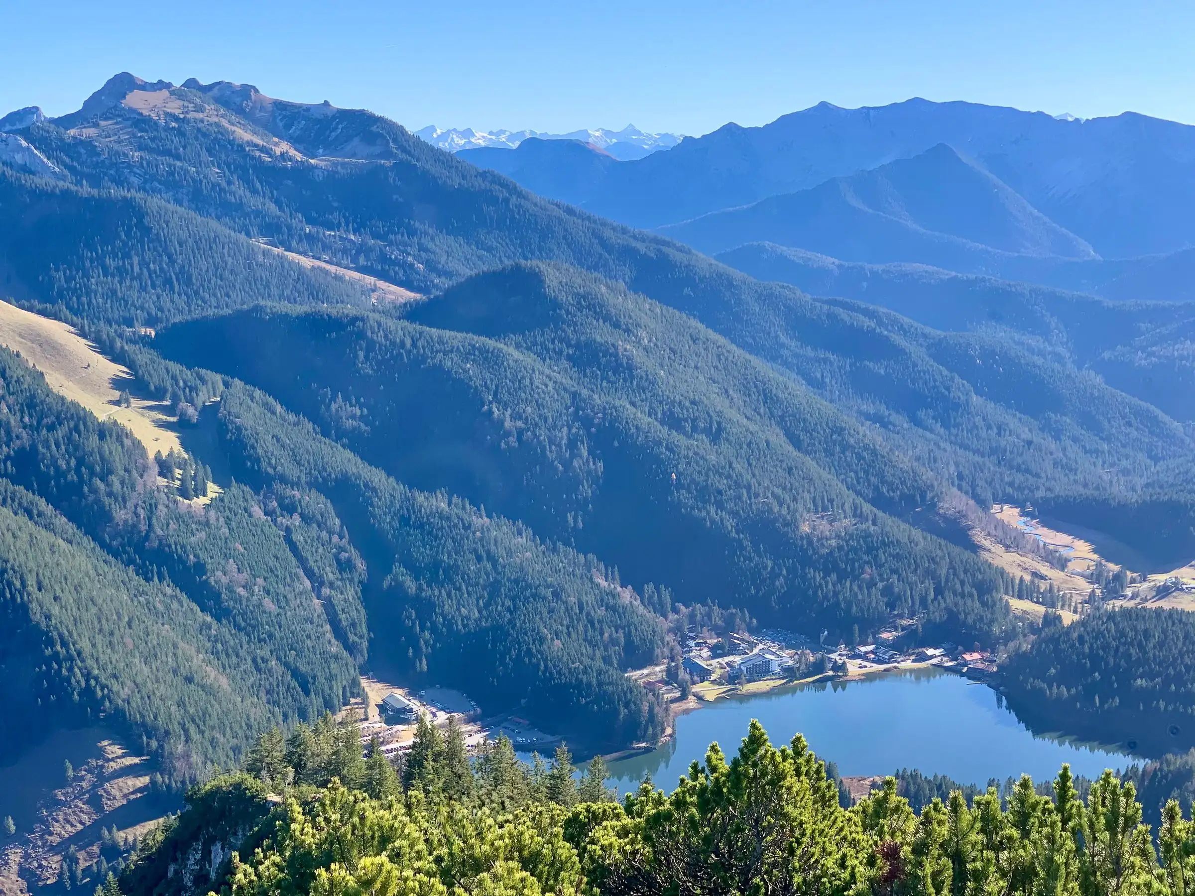
The Spitzingsee is a mountain lake at 1,084 metres (3,556 ft), about 70 km by road south-east of Munich, and the path around it is 3 to 3.5 km (around 2 miles) long, nearly flat and takes 45 minutes to an hour. It is kept clear in winter. You reach it by train from Munich to Schliersee and a 15-minute bus ride, free if you are staying in the area and hold a guest card.
The lake in numbers
3 to 3.5km around the lake
45minutes of walking
1,084metres above sea level
28.3hectares of water
What the Spitzingsee is
A small lake high up, a village of about two hundred people, and the mountains Munich goes walking in.
The lake sits in the Mangfall mountains, part of the Bavarian Prealps and among the ranges people in Munich call their “house mountains”, the ones close enough for a day. It lies five kilometres as the crow flies south of the Schliersee and 307 metres higher. It covers 28.3 hectares (about 70 acres): one of the largest mountain lakes in Bavaria, and still small enough to see the whole of it from any point on the shore.
Spitzingsee is also the name of the village on its eastern shore, part of the municipality of Schliersee, with roughly two hundred residents, a handful of hotels, a church and the lifts. In summer people come to hike the peaks around it, the Rotwand, Brecherspitz, Jägerkamp and Taubenstein. In winter they come to ski on the Stümpfling, to toboggan and to walk in the snow.
The loop around the lake is what you do when you have an hour, when the weather is too uncertain for a summit, or when you have small children with you. It is a stroll, not a hike.
The walk around Lake Spitzingsee
A promenade on the east shore, an undeveloped west shore, and a bridge at the south end.
Start at the bus stop “Spitzingsee Kirche”, in front of the church on the east shore, and cross the road to the water. If you drive, use one of the walkers’ car parks in the village just after the short tunnel.
Either direction works. The east side is a broad lakeside promenade past the village, the hotels and the boat hire. At the south end a bridge crosses the Rote Valepp, the stream that drains the lake, right next to the Alte Wurzhütte inn. The west shore has almost no buildings: the path runs under the Stümpfling close to the water, narrower and slightly sloping for a stretch.
In the north-west, where the Firstgraben stream comes down from the alpine pastures, the shore turns to reed beds and bog. It is protected, and it shows what the lake looked like before anyone lived on it. In one hour you see both faces of the place: a resort on one side, wild shore on the other.
Pushchairs are fine. The tourist board’s accessibility survey describes the path as partly tarmac and partly fine gravel, mostly 2.5 metres wide, with a few short climbs of around ten metres. Wheelchair users are advised to bring a companion for those. After the winter the surface can be rough until it has been repaired.
Spitzingsee in winter
The path is cleared, the lake is usually frozen, and the bus takes you to the start.
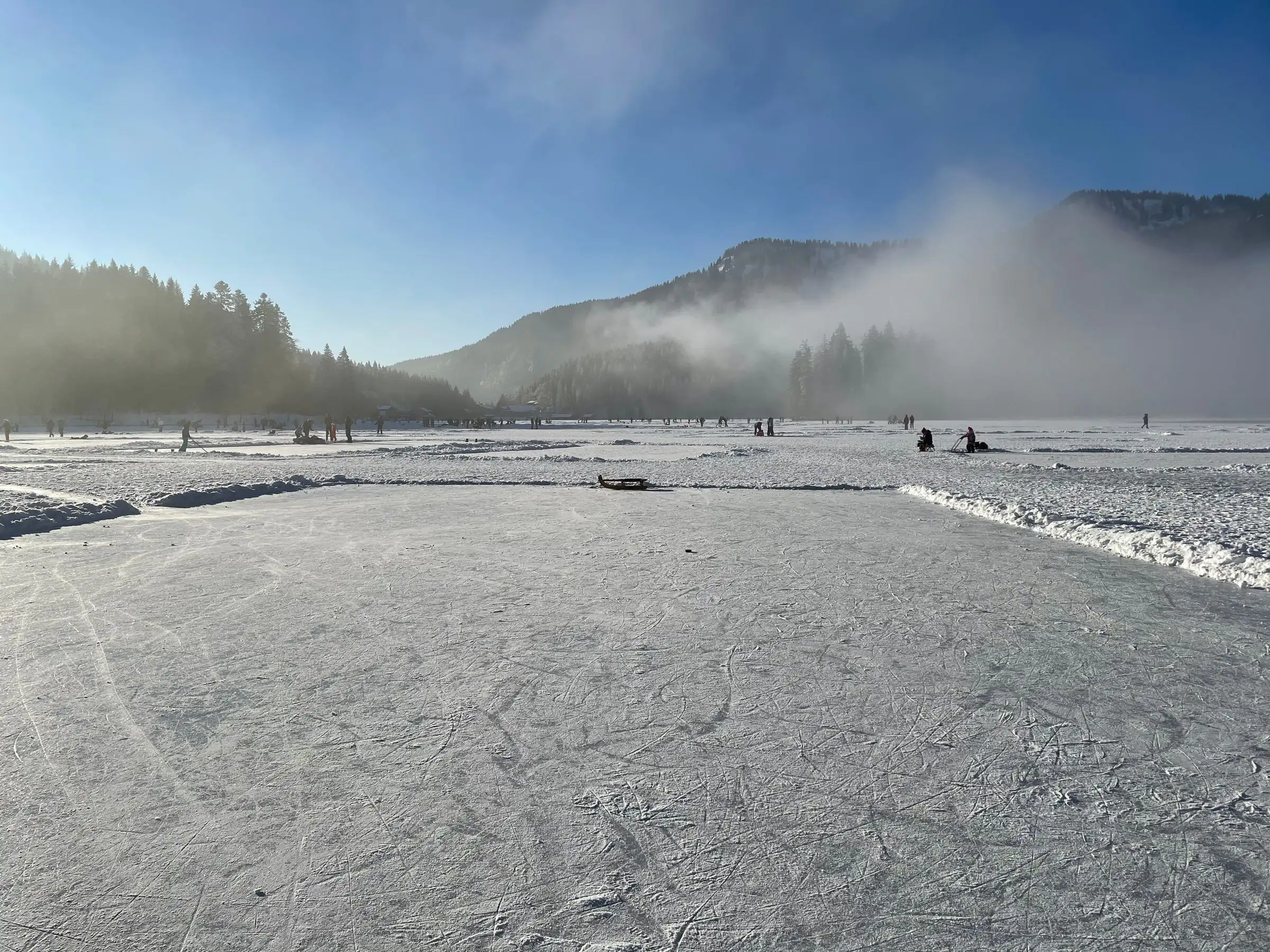
The winter walk around the Spitzingsee is the easiest way to be in proper snow without skis. The municipality clears the path and gives it as about 3 km and 45 minutes. Down at the Schliersee, at 777 metres, snow comes and goes. Up here, three hundred metres higher, it lies more reliably.
In midwinter the lake is usually frozen and snow-covered. Stay off the ice all the same: there is an inflow in the north-west and an outflow in the south, and the ice is thinner there than it looks. On cold days, slip-on spikes for your shoes (called Grödel locally) make the narrow west shore much easier.
Driving up on a winter weekend tests your patience. The car parks by the lifts fill early and charge more in winter than in summer. The ski bus is the better option: it runs hourly from the Seehotel Schlierseer Hof stop in Schliersee, a few minutes’ walk from our house, takes about fifteen minutes and is free with the guest card.
For more than a stroll, our hosts Ute and Markus Leitner send guests who ask about tobogganing up from the Spitzingsattel pass to the Obere Firstalm: hire a sledge, dress warmly, ideally bring ski goggles, and ride back down the forest road of about 2.5 km to the car park on the pass.
Can you swim in Lake Spitzingsee?
Yes, but at 1,084 metres the water reaches about 18 °C in high summer.
Swimming is allowed and possible at several points on the shore, most of them along the promenade on the east side. There is no designated public beach with changing rooms or a kiosk, and for small children the entry is often quite steep. Leave the reed and bog belt in the north-west alone: it is protected.
The water is cold. On sunny days in high summer it reaches about 18 °C (64 °F). The Schliersee down in the valley warms up to 23 °C (73 °F). If swimming is the point of your day, swim in the Schliersee and come up to the Spitzingsee to look. Our hosts recommend the public lido in Schliersee.
In summer the boat hire in the village usually has pedal, rowing and electric boats. Half an hour on the water shows you the whole lake from the middle, and children tend to prefer it to the cold. The lake belongs to the Free State of Bavaria and is managed by the Bavarian Palace and Lakes Administration.
How to get to the Spitzingsee from Munich
Train to Schliersee, then the bus. By car over a pass with gradients of up to 14 per cent.
By train and bus: the Bayerische Regiobahn (BRB) runs from München Hauptbahnhof to Schliersee without changing in about fifty minutes, roughly every hour and more often at peak times. From Schliersee station, bus 9562 climbs via Fischhausen-Neuhaus and the Spitzingsattel to the stop “Spitzingsee Kirche” at the start of the walk. Buses and trains here are part of the Munich transport network, MVV, so one ticket covers both, and the Deutschlandticket is valid on both.
If you stay overnight anywhere in Schliersee, you get a Gästekarte, a guest card issued by your hotel or apartment host. For Schliersee it works as a free ticket on all buses and on regional trains (second class) in MVV zones 6 to 9, and one dog per card travels free. The return trip to the Spitzingsee costs you nothing.
By car: take the A8 motorway towards Salzburg, exit Weyarn, drive via Miesbach to Schliersee and south on the B307 past Neuhaus, then turn right onto the Spitzingstraße. It climbs at up to 14 per cent over the Spitzingsattel pass at 1,129 metres and drops down to the lake. From Schliersee it is about 10 km and 15 to 20 minutes. There is no other road in.
Parking: there are several pay car parks in the village just after the tunnel, plus car parks at the Taubensteinbahn gondola, the Stümpflingbahn chairlift and the Kurvenlift. Charges are higher in winter, and on sunny weekends and in the school holidays they are often full by mid-morning. Current rates are posted at the machines.
Where to eat at the Spitzingsee
An inn with three centuries of history at the south end, an Alpine Club hut twenty minutes further on.
Two words you will see everywhere. A Hütte (hut) is a staffed mountain house, often run by the German Alpine Club (DAV), with simple hot food and usually beds. An Alm is a summer pasture with a farmhouse, some of which serve a Brotzeit, a cold plate of bread, cheese and sausage, to walkers. Both keep seasonal hours and close on certain days, so check before you set off.
Halfway round, at the south end of the lake, the Alte Wurzhütte has a lakeside terrace and a beer garden. The house traces its history back more than three hundred years, much of it involving gentian schnapps. On the east shore there are several hotel restaurants, the largest at the Arabella Alpenhotel on the promenade.
For a real hut, follow the Valepp stream downhill from the Wurzhütte. The Albert-Link-Hütte of the German Alpine Club sits at 1,053 metres, lower than the lake, about twenty minutes from the church, and is open all year. With this detour the loop becomes a walk of about 4 km and just over an hour.
Back in Schliersee, our Xaver restaurant is open Tuesday to Thursday from 5 pm and Friday to Sunday and on public holidays from 11.30 am, with the kitchen open until 9 pm. It is closed on Mondays. Take an afternoon bus down and you are in time for dinner.
Spitzingsee or Schliersee?
Fifteen minutes apart and on opposite sides of a watershed. Most visitors should see both.
The two lakes belong to the same municipality but drain in opposite directions. The Spitzingsattel pass is the watershed. The Schliersee flows north into the Mangfall river. The Spitzingsee flows south as the Rote Valepp, through Tyrol as the Brandenberger Ache, and reaches the Inn on the far side of the mountains.
The Schliersee is almost eight times larger, noticeably warmer, and has a passenger boat, an island and a town with a railway station. The Spitzingsee is smaller, higher and colder, ringed by peaks you can almost touch from the shore. Stay down by the Schliersee, spend your days up at the Spitzingsee.
The lake is also the starting point for the summits around it. Our hosts’ recommendation from here is the Rotwand via the Rotwandhaus hut and back, four to five hours. Their second favourite is just as long but only for experienced walkers with a head for heights: from the Spitzingsattel up the Brecherspitz and back via the Obere Firstalm.
The church by the bus stop, St. Bernhard, was built in 1937 and 1938 in local rubble stone and dedicated to Bernard of Menthon, patron saint of mountaineers and skiers. East of the lake the Taubensteinbahn gondola, built in 1971, still carries walkers uphill in summer, although skiing on that side ended in 2015.
At a glance
- Length
- 3 to 3.5 km (about 2 miles)
- Time
- 45 minutes to 1 hour
- Climbs
- a few short ones, about 10 m
- Surface
- tarmac and fine gravel
- Pushchairs
- yes, west shore narrow in places
- Winter
- cleared, spikes recommended
- Start
- bus stop Spitzingsee Kirche
- From Munich
- train to Schliersee, then bus 9562
- Water in summer
- about 18 °C (64 °F)
Addresses and sources
Every link goes to the operators themselves. Times and prices change, so please check them there.
Path around the Spitzingsee (German)
The regional tourist board’s checked description of the path: width, surface and gradients, also for wheelchairs and pushchairs.
Alpenbahnen Spitzingsee
Lifts and cable cars at the Spitzingsee, in winter and in summer.
MVV, guest card (German)
Where the Gästekarte counts as a ticket. For Schliersee: buses and regional trains in MVV zones 6 to 9.
Alte Wurzhütte
Inn and hotel at the south end of the lake, with a lakeside terrace and beer garden. Check opening times with them.
Albert-Link-Hütte
The German Alpine Club hut just below the lake in the Valepp valley. Current opening days on the section’s site.
Bayerische Regiobahn
Timetables and tickets for the line from München Hauptbahnhof to Schliersee.
Bavarian Palace and Lakes Administration
The lake belongs to the Free State of Bavaria. Here you find who manages it and which rules apply.
German Alpine Club (DAV)
Trail conditions, hut opening and safety advice for the mountains around the lake.
German Weather Service (DWD)
Mountain weather and warnings for the Miesbach district.
Common questions.
How long is the walk around Lake Spitzingsee?
Between 3 and 3.5 km (about 2 miles), depending on where you start. It takes around 45 minutes of walking, or an hour with stops. There are only a few short climbs of about ten metres.
Can you walk around the Spitzingsee in winter?
Yes. The municipality clears the path in winter, and the loop is then about 3 km and 45 minutes. Slip-on spikes help on icy days. Do not walk on the frozen lake.
Can you swim in the Spitzingsee?
Yes, at several spots, mostly along the east shore. There is no designated public beach, and the water only reaches about 18 °C (64 °F) in high summer. The Schliersee in the valley gets up to 23 °C (73 °F).
How do I get to the Spitzingsee from Munich without a car?
Take the BRB train from München Hauptbahnhof to Schliersee, about fifty minutes without changing, then bus 9562 to the stop Spitzingsee Kirche. Both are part of the MVV network, and the Deutschlandticket is valid on both.
Is the Spitzingsee walk suitable for pushchairs?
Yes. The path is partly tarmac and partly fine gravel, mostly 2.5 metres wide. There is one narrower, slightly sloping stretch on the west shore and a few short climbs.
Where can you park at the Spitzingsee?
In the pay car parks in the village just after the tunnel, or at the Taubensteinbahn, the Stümpflingbahn and the Kurvenlift. All charge a fee, more in winter, and fill early on sunny weekends. The bus from Schliersee avoids the problem.
Where can you eat at the Spitzingsee?
At the Alte Wurzhütte at the south end of the lake, with a terrace and beer garden, and in the hotel restaurants on the east shore. The German Alpine Club’s Albert-Link-Hütte, open all year, is about twenty minutes from the church.
Is the Spitzingsee worth a day trip from Munich?
For the walk alone, an hour is enough. Combine it with a summit, the Taubensteinbahn gondola in summer or tobogganing in winter and it fills a day. Staying in Schliersee puts you fifteen minutes away, with free buses on the guest card.
Read on
- Walking around the Schliersee
7.4 km around the lake in the valley, almost flat, with a boat to shorten it in summer.
- Skiing at the Spitzingsee
The ski area fifteen minutes from Schliersee by ski bus, free with the guest card.
- Rooms with a private sauna
Six rooms with their own Finnish sauna, a balcony and a direct view of the lake.
Start from here
Our house stands in the middle of the village, seven minutes on foot from the station and four from the water. Reception is happy to help with questions about the region, daily from 7:30 am to 8 pm on +49 8026 92921-0.